The Industries
The technology that we pioneer serves several industries and use cases. Here's where we are innovating and where we can show you our true potential.
Offshore Renewables
-
Site survey and inspection of the seabed and subsea structures: including cables, pipelines, and foundations. This information can be used to assess the site's suitability for renewable energy installations and identify any potential issues that need to be addressed.
-
Environmental monitoring: our AUVs can be equipped with sensors to monitor the environment around such infrastructure, including water quality, marine life, and weather conditions. This information can be used to optimize the design and operation of renewable energy installations, minimizing their impact on the environment.
-
Maintenance and repair: cleaning and inspection of subsea structures, as well as the installation and repair of cables and pipelines.
-
Security and surveillance: detecting and tracking potential threats, such as unauthorized vessels or divers.

Hydrographic
-
Inspection and Maintenance: of infrastructure such as pipelines, risers, and platforms. Providing high-resolution images and video of underwater assets enables operators to detect defects, corrosion, and other issues before they become significant problems.
-
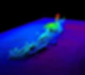
Exploration and Mapping: in areas that are difficult or impossible for human divers to reach. We can provide detailed 3D maps of the seafloor and subsea structures, which can be used to identify potential placement locations.
-
Security and Surveillance: such as monitoring underwater assets for unauthorized access, detecting potential threats, and providing real-time situational awareness.
-
Characterization Surveys: to assess the potential of the seabed, and identify geophysical/geological anomalies beneath the seafloor that pose an area of interest for further study. We can create detailed maps of the seafloor with the instruments onboard our vehicles.
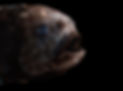
Oceanographic
-
Mapping and surveying: our vehicles are equipped with high-resolution cameras, sonars, and other sensors to create detailed maps of underwater habitats, including coral reefs, kelp forests, and seagrass beds. These maps can be used to identify marine protected areas (MPAs), and to monitor coservational variation over time.
-
Monitoring marine life: This information can be used to better understand their habitat requirements and identify areas where they are most at risk from human activities.
-
Studying oceanography: our vehicles are well equipped to collect data on water temperature, salinity, dissolved Oxygen and other important oceanographic parameters. This information can help researchers understand how ocean conditions affect marine ecosystems and identify areas that are particularly vulnerable to climate change.
-
Detecting and responding to environmental threats: with sensors to detect pollution, harmful algal blooms, and other environmental threats, we can enable rapid response to these threats and mitigate their impact on marine ecosystems.